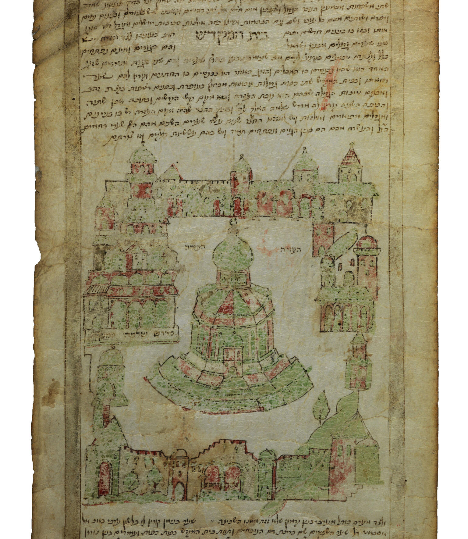
Map of the Temple in Jerusalem
Uri of Biella
1564
This map of the Temple in Jerusalem made in Safed by a Jewish scribe comes from an example of a “pilgrimage scroll,” also known as an “itinerary,” because they included instructions for visiting holy sites. Jewish pilgrimage scrolls from the mid-sixteenth century were stylistically modeled after Muslim scrolls and featured the Temple Mount as it was, with Muslim shrines such as the Dome of the Rock and Al-Aqsa Mosque.
Credits
The National Library of Israel, Jerusalem, Ms. Heb. 8°6947
Published in: The Posen Library of Jewish Culture and Civilization, vol. 5.
You may also like
Shevet Yehudah (The Staff of Judah)
The slaughter that occurred there, in Lisbon:
I was out of the city, and when I returned after several days they told me that the two [events, namely, the massacre within Lisbon and in the surrounding…
Seder Eliyahu zuta (The Minor Order of Elijah)
The Sultan Selim loved the Jews very much, for he realized that with their help he could strike nations and kill mighty kings. [ . . . ] And it came to pass on the third day, when the Sultan…

Prayer book
This siddur from Greece contains the prayers of the Romaniote (Greek-speaking Jewish) community of the eastern Mediterranean. It is open at a piyyut (liturgical poem) called “God’s Beloved Daughter,”…
Consolaçāo às tribulações de Israel (Consolation for the Tribulations of Israel)
[ . . . ] The Portuguese king, eager to find some logical excuse to vex me, called for an investigation to see if the number…
Divre ha-yamim le-malkhe Tsarefat u-vet Otoman ha-Togar (Chronicle of the Kings of France and the Ottoman Empire)
There was a man in Castile called Americo. He had a large ship, in which he placed a great number of supplies, as much as his soul desired, and he also resolved in his heart to amass as much booty as…
Crónica de los reyes otomanos (Chronicle of the Ottoman Kings)
The houses and rooms of the inhabitants of this most famous city are one or the other of two extremes: the good ones are sumptuous houses at the height of perfection and…
Engage with this Source
Creator Bio
Uri of Biella
16th Century
Uri of Biella was a scribe in Safed, creator of the sixteenth-century scroll known as Yiḥus ha-avot (Genealogy of the Patriarchs).
Related Guide
Birth of an Idea: Defining the Early Modern Period
1500–1750
The emergence of the early modern period (1500–1750) in Jewish history is relatively recent and complex.
Related Guide
Defining Trends of the Early Modern Period
1500–1750
Paradoxically, both centrifugal forces (expulsions, migrations creating global dispersion) and centripetal trends (Hebrew printing, kabbalah) unified Jews in the early modern period.
Related Guide
Early Modern Historical Narratives
1500–1750
The early modern period saw a flourishing of Jewish historical writing in genres ranging from apologetic treatises to chronicles of specific events.
You may also like
Shevet Yehudah (The Staff of Judah)
The slaughter that occurred there, in Lisbon:
I was out of the city, and when I returned after several days they told me that the two [events, namely, the massacre within Lisbon and in the surrounding…
Seder Eliyahu zuta (The Minor Order of Elijah)
The Sultan Selim loved the Jews very much, for he realized that with their help he could strike nations and kill mighty kings. [ . . . ] And it came to pass on the third day, when the Sultan…

Prayer book
This siddur from Greece contains the prayers of the Romaniote (Greek-speaking Jewish) community of the eastern Mediterranean. It is open at a piyyut (liturgical poem) called “God’s Beloved Daughter,”…
Consolaçāo às tribulações de Israel (Consolation for the Tribulations of Israel)
[ . . . ] The Portuguese king, eager to find some logical excuse to vex me, called for an investigation to see if the number…
Divre ha-yamim le-malkhe Tsarefat u-vet Otoman ha-Togar (Chronicle of the Kings of France and the Ottoman Empire)
There was a man in Castile called Americo. He had a large ship, in which he placed a great number of supplies, as much as his soul desired, and he also resolved in his heart to amass as much booty as…
Crónica de los reyes otomanos (Chronicle of the Ottoman Kings)
The houses and rooms of the inhabitants of this most famous city are one or the other of two extremes: the good ones are sumptuous houses at the height of perfection and…


